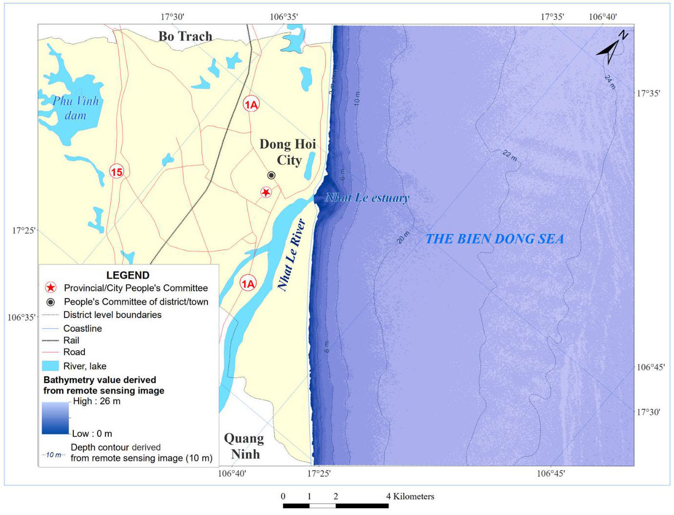
Development of a detailed bathymetry map of the Nhat Le estuary, Quang Binh province by remote sensing image treatment
Author affiliations
DOI:
https://doi.org/10.15625/0866-7136/20660Keywords:
bathymetry, mapping, satellite image, reflectance spectrum, Landsat 8 OLI image, Nhat Le EstuaryAbstract
Multispectral remote sensing images with the advantages of low cost, wide area coverage, and increased resolution have been widely used recently for determining the bathymetry of coastal waters. In this study, the correlation equation is developed based on the Landsat 8 OLI satellite images captured on September 22, 2022, and the survey data measured during the time period of September 12–22, 2022, was used for mapping bathymetry in the Nhat Le Estuary area, Quang Binh Province, a relatively clear area from sediment. The correlation between the image and the field survey data is quite good, with R2 = 0.88. This shows that Landsat 8 OLI data is suitable for mapping sea areas with depths up to 20 m.
Downloads
References
[1] T. A. Kearns and J. Breman. Bathymetry-The art and science of seafloor modeling for modern applications. Ocean Globe, 2010, (2010), pp. 1–36.
[2] E. K. Mccaffrey. A review of the bathymetric swath survey system. The International Hydrographic Review, (1981).
[3] N. Sánchez-Carnero, S. Aceña, D. Rodríguez-Pérez, E. Couñago, P. Fraile, and J. Freire. Fast and low-cost method for VBES bathymetry generation in coastal areas. Estuarine, Coastal and Shelf Science, 114, (2012), pp. 175–182.
[4] J. L. Irish and W. J. Lillycrop. Scanning laser mapping of the coastal zone: the SHOALS system. ISPRS Journal of Photogrammetry and Remote Sensing, 54, (1999), pp. 123–129.
[5] H. Ogawa, K. Oyakawa, K. Kawai, H. Ozawa, H. Yajima, H. Shirane, H. Yamano, N. Hirata, N. Iwamoto, T. Ono. Airborne lidar bathymetry. Int. Hydrographic Bureau, (2017), pp. 39–48.
[6] Sutanto. Penginderaan Jauh Jilid. Gadjah Mada Press, Yogyakarta, (1992).
[7] D. R. Lyzenga. Passive remote sensing techniques for mapping water depth and bottom features. Applied Optics, 17, (1978).
[8] D. R. Lyzenga. Remote sensing of bottom reflectance and water attenuation parameters in shallow water using aircraft and Landsat data. International Journal of Remote Sensing, 2, (1981), pp. 71–82.
[9] R. P. Stumpf, K. Holderied, and M. Sinclair. Determination of water depth with high-resolution satellite imagery over variable bottom types. Limnology and Oceanography, 48, (2003), pp. 547–556.
[10] A. Misra, Z. Vojinovic, B. Ramakrishnan, A. Luijendijk, and R. Ranasinghe. Shallow water bathymetry mapping using Support Vector Machine (SVM) technique and multispectral imagery. International Journal of Remote Sensing, 39, (2018), pp. 4431–4450.
[11] J. Pushparaj and A. V. Hegde. Estimation of bathymetry along the coast of Mangaluru using Landsat-8 imagery. The International Journal of Ocean and Climate Systems, 8, (2017), pp. 71–83.
[12] I. E. Setiawan, D. M. Yuwono, V. P. Siregar, and G. H. Pramono. The study of sea bottom morphology and bathymetric mapping using worldview-2 imagery. In Seminar Proceeding, Citeseer, (2013), pp. 143–149.
[13] X. Li and M. C. J. Damen. Coastline change detection with satellite remote sensing for environmental management of the Pearl River Estuary, China. Journal of Marine Systems, 82, (2010), pp. S54–S61.
[14] S. Toure, O. Diop, K. Kpalma, and A. S. Maiga. Shoreline detection using optical remote sensing: A review. ISPRS International Journal of Geo-Information, 8, (2019).
[15] I. Caballero and R. P. Stumpf. Retrieval of nearshore bathymetry from Sentinel-2A and 2B satellites in South Florida coastal waters. Estuarine, Coastal and Shelf Science, 226, (2019).
[16] T. Sagawa, Y. Yamashita, T. Okumura, and T. Yamanokuchi. Satellite derived bathymetry using machine learning and multi-temporal satellite images. Remote Sensing, 11, (2019).
[17] E. Evagorou, C. Mettas, A. Agapiou, K. Themistocleous, and D. Hadjimitsis. Bathymetric maps from multi-temporal analysis of Sentinel-2 data: the case study of Limassol, Cyprus. Advances in Geosciences, 45, (2019), pp. 397–407.
[18] C. Giardino, G. Candiani, M. Bresciani, Z. Lee, S. Gagliano, and M. Pepe. BOMBER: A tool for estimating water quality and bottom properties from remote sensing images. Computers & Geosciences, 45, (2012), pp. 313–318.
[19] C. J. Legleiter, D. A. Roberts, and R. L. Lawrence. Spectrally based remote sensing of river bathymetry. Earth Surface Processes and Landforms, 34, (2009), pp. 1039–1059.
[20] P. Q. Yen, D. K. Hoai, and D. T. B. Hoa. Research Bathymetry Mapping of ShallowWater Areas around Islands in the Truong Sa Archipelago by Deep - Remote sensing technology. VNU Journal of Science: Earth and Environmental Sciences, 33, (2017).
[21] D. X. Tinh, T. T. Tung, and T. D. Hung. Analysis of coastal seabed topography changes in Tien Chau estuary, Phu Yen province using Sentinel-2 images. Hydrometeorological Journal, 760, (2024).
[22] D. V. Phong. Research on the application of satellite images to supplement and update depth charts in Vietnam’s coastal waters, (2022).
[23] P. Jagalingam, B. J. Akshaya, and A. V. Hegde. Bathymetry mapping using Landsat 8 satellite imagery. Procedia Engineering, 116, (2015), pp. 560–566.
[24] N. T. Hung, V. D. Cuong, and N. V. Hung. Research on seasonal fluctuations of hydrodynamic regime in Nhat Le estuary area, Quang Binh province. Journal Science and Technology Water Resources, 48, (2018).
Downloads
Published
How to Cite
License

This work is licensed under a Creative Commons Attribution-ShareAlike 4.0 International License.
Funding data
-
Vietnam Academy of Science and Technology
Grant numbers CT0000.04/21-22


